File:Ely Homestead.jpg
Jump to navigation
Jump to search

Size of this preview: 800 × 600 pixels. Other resolutions: 320 × 240 pixels | 640 × 480 pixels | 1,024 × 768 pixels | 1,280 × 960 pixels | 2,560 × 1,920 pixels | 2,816 × 2,112 pixels.
Original file (2,816 × 2,112 pixels, file size: 2.77 MB, MIME type: image/jpeg)
This is a file from the Wikimedia Commons and may be used by other projects. Information from its description page there is shown below.
Commons is a freely licensed media file repository. |
|
This is an image of a place or building that is listed on the National Register of Historic Places in the United States of America. Its reference number is 76000036. |
| Camera location | | View this and other nearby images on: OpenStreetMap |
|---|
| Description |
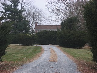
English: Driveway to the Ely Homestead, located at 4106 E. 200N northeast of Lafayette in northeastern Fairfield Township, Tippecanoe County, Indiana, United States. Built in 1877, it is listed on the National Register of Historic Places. |
||
| Date | Taken on 20 November 2010 | ||
| Source | Own work | ||
| Author | Nyttend | ||
| Permission (Reusing this file) |
|
File history
Click on a date/time to view the file as it appeared at that time.
| Date/Time | Thumbnail | Dimensions | User | Comment | |
|---|---|---|---|---|---|
| current | 16:04, 23 December 2010 | | 2,816 × 2,112 (2.77 MB) | Nyttend | {{Location|40|25|33|N|86|52|21|W}} {{Information |Description={{en|Driveway to the {{w|Ely Homestead}}, located at 4106 E. 200N northeast of {{w|Lafayette, Indiana|Lafayette}} in northeastern {{w|Fairfield Township, Tippecanoe County, Indiana|Fairfield To |
File usage
There are no pages that use this file.
Global file usage
The following other wikis use this file:
- Usage on en.wikipedia.org
- Usage on www.wikidata.org