Talk:Northern Quebec
Latest comment: 3 years ago by Shaundd in topic Holes in the map
Holes in the map[edit]
Why are there holes in the map (two large ones and several smaller ones in Baie-James)? Is this an OpenStreetMap error, or do the mapshape templates need to be adjusted? —Granger (talk · contribs) 13:53, 23 May 2020 (UTC)
- It's definitely incorrect, though the holes are in the wrong places—they should exist. --Comment by Selfie City (talk | contributions) 14:00, 23 May 2020 (UTC)
- The mapshapes come from Wikidata, and over the last few months I've stumbled upon a few instances where mapshapes don't look normal. --Ypsilon (talk) 14:10, 23 May 2020 (UTC)
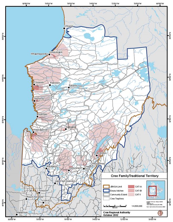
- I find First Nations reserves are sometimes edited out of (Canadian) provincial administrative mapshapes on OpenStreetMap. Looking at this map of Cree territory around James Bay, two of the pink areas (the reserves) match the holes in the mapshape, so I think that's what happened here, too. I'm not sure there's much we can do about it since we're just pulling the data from OpenStreetMap. -Shaundd (talk) 14:42, 23 May 2020 (UTC)
- Could the reservations be included on the map? --Comment by Selfie City (talk | contributions) 14:49, 23 May 2020 (UTC)
- Yes, if the reservations have Wikidata items that are connected to OSM, we should be able to add them to the map with the same color as the rest of Baie-James. —Granger (talk · contribs) 15:28, 23 May 2020 (UTC)
- We definitely could, although arguably it would be helpful to include them in a separate color. That could be considered ttcf as it would show where reservations are located, but might contradict consensus/policy. --Comment by Selfie City (talk | contributions) 15:30, 23 May 2020 (UTC)
- I'm not sure if it's helpful. I haven't read the Northern Quebec article, but my thinking is if we don't call out the reserves in the guide and we don't treat them as a separate region, why would we use a different colour? To me that seems more confusing since the map is supposed to show our regions and we'd have colours that don't match anything in the article. It would also be inconsistent with how reserves are shown elsewhere. -Shaundd (talk) 16:10, 23 May 2020 (UTC)
- I was wondering if that was the case, so therefore I think it would be best to include the reservations in the same colour as other places. In some U.S. states such as Arizona, reservations are an important region in themselves, but I guess that's not the case in this part of Quebec. --Comment by Selfie City (talk | contributions) 16:12, 23 May 2020 (UTC)
- Or just indicate in the caption that white indicates First Nations reserves. That would be the easiest solution. Someone may have reason to write about them in the future. The problem is that not all FN reserves are indicated. I don't know why just the ones in Baie-James are. Ground Zero (talk) 17:38, 23 May 2020 (UTC)
- I agree it would be easy, at the same time, the Baie-James guide includes the reserves as part of the region. I think it would be best if the reserves were coloured the same as the rest of the Baie-James region.
- Re why just the ones in Baie-James are excluded from the mapshape, it's something I've seen before in BC's regional districts. OSM is more or less a wiki, just like us. In the case of Baie-James, the shape started off as the "official" one from GeoBase (open source portal of Canadian geographic info, but it's called something else now). Over time, people have edited the shape to what it is now. The edits to carve out the reserves happened a year ago or so ago if I'm understanding the history of the relation properly. And I guess, just like us, editors aren't consistent, so someone edits the reserves out of Baie-James but doesn't do it for the other regions. -Shaundd (talk) 19:32, 23 May 2020 (UTC)
- Update: I poked around OSM and it appears there isn't a mapshape that covers the holes in the James Bay mapshape. I don't know how to undo the edits that made the holes (there have been several edits made in the interim so it's not a simple undo) so I support leaving it white for now.
- As a FYI, I also looked into what those holes represent and they're a combination of Cree village, lands reserved for the Cree and what's called Category II lands, which under a 2012 agreement between the Cree and the Quebec government, is land owned by the Quebec government but managed and largely governed by the Cree. If I understood the agreement properly, it only applies to Category II lands in the James Bay district, so it would help explain why we don't see those holes in other mapshapes. -Shaundd (talk) 04:19, 24 May 2020 (UTC)
- Thanks for doing that research. I think the current map is confusing, and it doesn't match our region structure because our Baie-James article includes cities located in the holes on the map. So I do think this needs to be fixed, but I don't know how we can do that other than by editing OSM. Could we make a static map instead? —Granger (talk · contribs) 12:50, 24 May 2020 (UTC)
- Recently I came upon a website that could be used to create static maps more easily than the current method. I’ll post in the pub later today and it could be applied to this article. --Comment by Selfie City (talk | contributions) 15:29, 24 May 2020 (UTC)
- I agree, I was thinking a static map would be the best solution here. @SelfieCity: were you thinking of making a map based on the website you found, or were you just going to post a link to the website? I should be able to make a static map fairly easily as I have the needed datasets from Stats Can.
- BTW, I also changed my reference to "reserves" above to "Cree villages and lands reserved for the Cree", which is how it's referenced by government documents and Wikipedia. -Shaundd (talk) 16:37, 24 May 2020 (UTC)
- @Shaundd: See Wikivoyage:Travellers' pub#Possible way to generate static maps. --Comment by Selfie City (talk | contributions) 17:03, 24 May 2020 (UTC)
- I've added a first cut of the static region map. I still need to add roads and some more names, but please let me know if you have any other comments. -Shaundd (talk) 06:11, 25 May 2020 (UTC)
- @Shaundd: See Wikivoyage:Travellers' pub#Possible way to generate static maps. --Comment by Selfie City (talk | contributions) 17:03, 24 May 2020 (UTC)
- Recently I came upon a website that could be used to create static maps more easily than the current method. I’ll post in the pub later today and it could be applied to this article. --Comment by Selfie City (talk | contributions) 15:29, 24 May 2020 (UTC)
- Thanks for doing that research. I think the current map is confusing, and it doesn't match our region structure because our Baie-James article includes cities located in the holes on the map. So I do think this needs to be fixed, but I don't know how we can do that other than by editing OSM. Could we make a static map instead? —Granger (talk · contribs) 12:50, 24 May 2020 (UTC)
- Or just indicate in the caption that white indicates First Nations reserves. That would be the easiest solution. Someone may have reason to write about them in the future. The problem is that not all FN reserves are indicated. I don't know why just the ones in Baie-James are. Ground Zero (talk) 17:38, 23 May 2020 (UTC)
- I was wondering if that was the case, so therefore I think it would be best to include the reservations in the same colour as other places. In some U.S. states such as Arizona, reservations are an important region in themselves, but I guess that's not the case in this part of Quebec. --Comment by Selfie City (talk | contributions) 16:12, 23 May 2020 (UTC)
- I'm not sure if it's helpful. I haven't read the Northern Quebec article, but my thinking is if we don't call out the reserves in the guide and we don't treat them as a separate region, why would we use a different colour? To me that seems more confusing since the map is supposed to show our regions and we'd have colours that don't match anything in the article. It would also be inconsistent with how reserves are shown elsewhere. -Shaundd (talk) 16:10, 23 May 2020 (UTC)
- We definitely could, although arguably it would be helpful to include them in a separate color. That could be considered ttcf as it would show where reservations are located, but might contradict consensus/policy. --Comment by Selfie City (talk | contributions) 15:30, 23 May 2020 (UTC)
- Yes, if the reservations have Wikidata items that are connected to OSM, we should be able to add them to the map with the same color as the rest of Baie-James. —Granger (talk · contribs) 15:28, 23 May 2020 (UTC)
- Could the reservations be included on the map? --Comment by Selfie City (talk | contributions) 14:49, 23 May 2020 (UTC)
- I find First Nations reserves are sometimes edited out of (Canadian) provincial administrative mapshapes on OpenStreetMap. Looking at this map of Cree territory around James Bay, two of the pink areas (the reserves) match the holes in the mapshape, so I think that's what happened here, too. I'm not sure there's much we can do about it since we're just pulling the data from OpenStreetMap. -Shaundd (talk) 14:42, 23 May 2020 (UTC)
- The mapshapes come from Wikidata, and over the last few months I've stumbled upon a few instances where mapshapes don't look normal. --Ypsilon (talk) 14:10, 23 May 2020 (UTC)
Wow, it looks excellent. It’s definitely better than the dynamic map in this case. --Comment by Selfie City (talk | contributions) 11:23, 25 May 2020 (UTC)
- Thanks. Version 2 of the map (roads added) is now up. -Shaundd (talk) 06:43, 27 May 2020 (UTC)